
The Yorkshire Dales are limestone country: pale scars, dry valleys, potholes that swallow whole streams, and drystone walls running up hillsides in a pattern that has not changed in three hundred years. Above the limestone sit caps of gritstone, and it is these that make the three famous summits. The Three Peaks challenge draws tens of thousands of walkers a year to a single circuit, but the national park covers 2,179 square kilometres, and most of it sees very few. This is a guide to the challenge walk, and to what lies beyond it.
The Three Peaks circuit: the facts
The route links Pen-y-ghent at 694 metres, Whernside at 736 metres and Ingleborough at 723 metres in a single circuit of about 39 kilometres with around 1,600 metres of ascent. The traditional start and finish is the village of Horton-in-Ribblesdale, which has a station on the Settle to Carlisle line, and the traditional target is to complete the walk in under twelve hours. Most people go clockwise: Pen-y-ghent first, its steep southern nose giving the only real scramble of the day; then the long moorland trudge north to the Ribblehead viaduct; Whernside by its northern ridge, the highest point in the county; and finally Ingleborough, whose flat summit plateau carries the remains of an Iron Age enclosure.
Whernside is the least interesting of the three to look at and the most rewarding to stand on, with a view west to Morecambe Bay and the Lakeland fells. Ingleborough is the finest hill, a stepped profile visible from half of northern England. Pen-y-ghent, the smallest, is the one walkers remember with most affection.
Timing, season and the long day
Twelve hours is a fair target for a fit walker at a steady pace with short stops. The path is well made for most of its length, and route-finding is straightforward in clear weather, but the moorland between Pen-y-ghent and Ribblehead and the descent of Ingleborough to Horton are wet and slow in a bad season. We would not attempt the full round in winter without a very early start and a head torch; from November to February the daylight simply does not stretch.
The best months are May, June and September. Weekends between Easter and October are busy, and charity events can put several hundred people on the route at once. A weekday in late spring, starting at six in the morning, gives a quiet Pen-y-ghent and a chance of finishing before the light goes. Carry more water than seems sensible: there is none reliable on the tops, and the section over Whernside is long and exposed.
Ribblehead and the railway
The Ribblehead viaduct is the centrepiece of the circuit and the reason many people come. Built between 1870 and 1874, it carries the Settle to Carlisle line across Batty Moss on twenty-four arches, 400 metres long and 32 metres high at its tallest. The navvies who built it lived in shanty towns on the moor, and around a hundred of them died of accidents and disease during the work; their graves are in the churchyard at Chapel-le-Dale. The line itself climbs to a summit of 356 metres at Ais Gill, and every station along it is a walkers’ station. Ribblehead station lies at the viaduct’s southern end, so the Three Peaks can be broken here, and the train used to link Horton, Ribblehead and Dent for shorter days on individual hills.
The limestone: Malham, Ingleborough and underground
South of the Three Peaks the limestone reaches its most dramatic. Malham Cove is a curved cliff of pale rock eighty metres high, with a limestone pavement on its lip and a stream that emerges at its foot; the walk up the dry valley of Watlowes to Malham Tarn, and back by the gorge of Gordale Scar, is a half day that packs in more geology than most mountain ranges. On the flanks of Ingleborough, the pavements at Southerscales and the pothole of Gaping Gill, where Fell Beck drops 98 metres into a chamber large enough to hold a cathedral, are reachable from Clapham on the Ingleborough ascent from the south.
Much of this landscape is underground. The Dales contain the longest cave systems in Britain, and the potholes that dot the moors are their entrances. From above they are simply holes to avoid in mist; the Three Peaks path passes close to Hull Pot, a chasm 90 metres long on the western side of Pen-y-ghent, which fills with a waterfall after rain.
Beyond the challenge: the quiet Dales
The Three Peaks are a fine day, but they are not the Dales. The national park, created in 1954 and extended west in 2016, has a dozen valleys and a hundred summits that the challenge walkers never see.
- Wharfedale: Buckden Pike at 702 metres and Great Whernside at 704 metres, both higher than Ingleborough and both almost empty, above the villages of Kettlewell and Buckden.
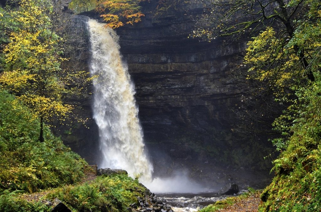
- Wensleydale: Hardraw Force, at about thirty metres the highest single-drop waterfall above ground in England, and the long ridge of Great Shunner Fell on the Pennine Way.
- Swaledale: the most remote of the main dales, with lead-mining ruins on the moors above Gunnerside and the Pennine Way crossing at Keld.
- Dentdale: reached from Dent station, the highest on the main line, with the Dales Way running its length along the river.
- The Howgill Fells: smooth grassy hills between the Dales and the Lakes, added to the park in 2016, with the 200-metre cascade of Cautley Spout on their eastern side.
Long-distance options
Two national routes cross the area. The Pennine Way passes over Pen-y-ghent and Great Shunner Fell on its way north, and the section from Horton to Keld makes a fine three-day walk. The Dales Way runs 130 kilometres from Ilkley to Bowness-on-Windermere, following the Wharfe, the Dee and the Lune, and is one of the gentlest long walks in Britain, suitable for a first week with a pack. Both are well served by the railway at their Dales ends, which returns us to the point: this is a landscape you can walk from the platform, and the best of it is not on the Three Peaks path at all.
Read next: The Bothy Code Explained: What It Asks, and Why It Matters